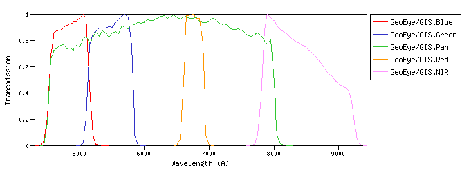
GeoEye :The GeoEye-1 satellite sensor was successfully launched on September 6, 2008. GeoEye-1 is capable of acquiring image data at 0.46 meter panchromatic (B&W) and 1.84 meter multispectral resolution. GeoEye/GIS :GIS (GeoEye Imaging System) is a pushbroom imaging system whose basic elements are the optics subsystem (telescope assembly), the focal plane assembly (CCD detector), and the digital electronics subsystem.id:GeoEye/GIS.a |
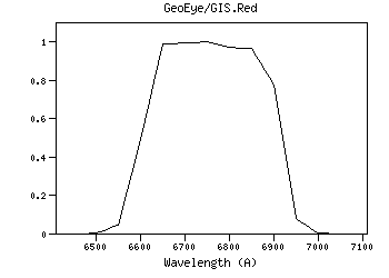
| GeoEye/GIS.Blue | 4834.41 | 4845.28 | 4822.95 | 4406.67 | 5265.00 | 583.53 | 3981.82 | 5.11e-9 | GeoEye | GIS | GeoEye-1 GIS Blue normalized spectral response | | GeoEye/GIS.Green | 5466.38 | 5477.95 | 5455.13 | 5020.00 | 5898.00 | 646.13 | 3629.66 | 3.64e-9 | GeoEye | GIS | GeoEye-1 GIS Green normalized spectral response | | GeoEye/GIS.Pan | 6069.83 | 6302.43 | 5841.30 | 4451.56 | 8125.00 | 3074.36 | 3331.55 | 2.71e-9 | GeoEye | GIS | GeoEye-1 GIS Panchromatic normalized spectral response | | GeoEye/GIS.Red | 6755.31 | 6757.45 | 6754.72 | 6507.78 | 6996.25 | 316.31 | 2875.48 | 1.89e-9 | GeoEye | GIS | GeoEye-1 GIS Red normalized spectral response | | GeoEye/GIS.Red | Filter Description | Filter ID (?) : | GeoEye/GIS.Red |
| Description (?) : | GeoEye-1 GIS Red normalized spectral response |
| Phot.System (?) : | GIS |
| Detector Type (?) : | Energy counter |
| Band Name (?) : | Red |
| Obs. Facility (?) : | GeoEye |
| Instrument (?) : | GIS |
| Comments (?) : | ------ |
| | Mathematical properties | Property | Calculated | Specified | Unit | | λref (?) : |
6755.31 | ------- | (Angstrom) |
| λmean (?) : |
6757.45 | ------- | (Angstrom) |
| λcen (?) : |
6760.45 | ------- | (Angstrom) |
| λeff (?) : |
6754.72 | ------- | (Angstrom) |
| λpeak (?) : |
6750.00 | ------- | (Angstrom) |
| λpivot (?) : |
6755.31 | ------- | (Angstrom) |
| λphot (?) : |
6756.12 | ------- | (Angstrom) |
| λmin (?) : |
6507.78 | ------- | (Angstrom) |
| λmax (?) : |
6996.25 | ------- | (Angstrom) |
| Weff (?) : |
316.31 | ------- | (Angstrom) |
| FWHM (?) : |
319.10 | ------- | (Angstrom) |
| Af/AV (?) : |
0.772 | ------- | () |
| Fsun (?) : |
150.94 | ------- | (erg/cm2/s/A) |
| Transmission
Data file: ascii, VOTable Reference for filter response:
Apollo Mapping Transmission components: Filter + Instrumentid:GeoEye/GIS.Red | | Calibration properties
Vega System | Property | Specified | Calculated | Unit | | Zero Point (?) : |
------- |
1.88904e-9 | (erg/cm2/s/A) |
| |
------- |
2875.48 | (Jy) |
| ZP Type (?) : |
Pogson |
| PhotCal ID (?) : |
GeoEye/GIS.Red/Vega |
| |
AB System | Property | Specified | Calculated | Unit | | Zero Point (?) : |
------- |
2.38537e-9 | (erg/cm2/s/A) |
| |
------- |
3631.00 | (Jy) |
| ZP Type (?) : |
Pogson |
| PhotCal ID (?) : |
GeoEye/GIS.Red/AB |
| |
ST System | Property | Specified | Calculated | Unit | | Zero Point (?) : |
------- |
3.631e-9 | (erg/cm2/s/A) |
| |
------- |
5527.08 | (Jy) |
| ZP Type (?) : |
Pogson |
| PhotCal ID (?) : |
GeoEye/GIS.Red/ST |
| |
|
Filter added: 2020-08-30 21:16:07
Last update: 2021-07-27 19:15:19 | | GeoEye/GIS.NIR | 8384.63 | 8412.42 | 8365.45 | 7685.00 | 9335.00 | 1011.88 | 2313.73 | 9.87e-10 | GeoEye | GIS | GeoEye-1 GIS NIR normalized spectral response |
| Filter Plots
 |
|
| 
 ≡ filter transmission<p><u>Property info:</u><ul><li><b>Unit</b>:Angstrom<li><b>UCD</b>:em.wl</ul></td></table>',WIDTH,400))
 ≡ filter transmission<br> Vg(λ) ≡ Vega spectrum.<p><u>More info:</u><p>Vega spectrum from calspec database.<ul><li><a href="https://ui.adsabs.harvard.edu/abs/2014PASP..126..711B/abstract" target="_blank">Bohlin, Gordon, & Tremblay (2014)</a>.<li><a href="https://www.stsci.edu/hst/instrumentation/reference-data-for-calibration-and-tools/astronomical-catalogs/calspec" target="_blank">STScI current calspec</a>.<li><a href="morefiles/vega.dat" target="_blank">Vega spectrum file</a> (units: Angstrom erg/cm2/s/A).</ul><p><u>Property info:</u><ul><li><b>Unit</b>:Angstrom<li><b>UCD</b>:em.wl.effective</ul></td></table>',WIDTH,400))
 ≡ filter transmission<p>Equivalent to the horizontal size of a rectangle with height equal to maximum transmission and with the same area that the one covered by the filter transmission curve.<p><u>Property info:</u><ul><li><b>Unit</b>:Angstrom<li><b>UCD</b>:instr.bandwidth<li><b>Utype</b>: <i>photdm:PhotometryFilter.bandwidth.extent.value</i></ul></td></table>',WIDTH,400))
 ≡ filter transmission (energy counter).<br> Vg(λ) ≡ Vega spectrum.<p><i>(T(λ) must be multiplied by λ for photon counting devices)</i><p>F<sub>0,ν</sub>(Jy) = (2.9979246)<sup>-1</sup> 10<sup>5</sup> * λ<sub>ref</sub><sup>2</sup> * F<sub>0,λ</sub>(erg/cm<sup>2</sup>/s/A)<p>In the case that filter owner specifies its own values, they will be the ones provided by the service when queried through the VO.<p><u>Property info:</u><ul><li><b>Unit</b>:Jy<li><b>UCD</b>:phot.flux.density<li><b>Utype</b>: <i>photdm:PhotCal.zeroPoint.flux.value</i></ul></td></table>',WIDTH,400))
 ≡ filter transmission (energy counter).<br> Vg(λ) ≡ Vega spectrum.<p><i>(T(λ) must be multiplied by λ for photon counting devices)</i><p><u>Property info:</u><ul><li><b>Unit</b>:erg/cm2/s/A<li><b>Utype</b>: <i>PhotCal.ZeroPoint</i></ul></td></table>',WIDTH,400))
 ≡ filter transmission<p>f(λ) ≡ flux of the spectrum<p><u>Property info:</u><ul><li><b>UCD</b>:meta.code<li><b>Utype</b>: <i>photdm:PhotometricSystem.detectorType</i></ul></td></table>',WIDTH,400))
 ≡ filter transmission<p><img src=showgraph.php?what=lmean&val=6757.445860074&id=GeoEye/GIS.Red><p><u>Property info:</u><ul><li><b>Unit</b>:Angstrom<li><b>UCD</b>:em.wl</ul></td></table>',STICKY,true,CLOSEBTN,true,WIDTH,400))
 ≡ filter transmission<br> Vg(λ) ≡ Vega spectrum.<p><img src=showgraph.php?what=leff&val=6754.7225244522&id=GeoEye/GIS.Red><p><u>More info:</u><p>Vega spectrum from calspec database.<ul><li><a href="https://ui.adsabs.harvard.edu/abs/2014PASP..126..711B/abstract" target="_blank">Bohlin, Gordon, & Tremblay (2014)</a>.<li><a href="https://www.stsci.edu/hst/instrumentation/reference-data-for-calibration-and-tools/astronomical-catalogs/calspec" target="_blank">STScI current calspec</a>.<li><a href="morefiles/vega.dat" target="_blank">Vega spectrum file</a> (units: Angstrom erg/cm2/s/A).</ul><p><u>Property info:</u><ul><li><b>Unit</b>:Angstrom<li><b>UCD</b>:em.wl.effective</ul></td></table>',STICKY,true,CLOSEBTN,true,WIDTH,400))
 ≡ filter transmission<p><img src=showgraph.php?what=lpiv&val=6755.3102010428&id=GeoEye/GIS.Red><p><u>Property info:</u><ul><li><b>Unit</b>:Angstrom<li><b>UCD</b>:em.wl</ul></td></table>',STICKY,true,CLOSEBTN,true,WIDTH,400))
 ≡ filter transmission<br> Vg(λ) ≡ Vega spectrum<p><img src=showgraph.php?what=lphot&val=6756.1191325611&id=GeoEye/GIS.Red><p><u>More info:</u><p>Vega spectrum from calspec database.<ul><li><a href="https://ui.adsabs.harvard.edu/abs/2014PASP..126..711B/abstract" target="_blank">Bohlin, Gordon, & Tremblay (2014)</a>.<li><a href="https://www.stsci.edu/hst/instrumentation/reference-data-for-calibration-and-tools/astronomical-catalogs/calspec" target="_blank">STScI current calspec</a>.<li><a href="morefiles/vega.dat" target="_blank">Vega spectrum file</a> (units: Angstrom erg/cm2/s/A).</ul><p><u>Property info:</u><ul><li><b>Unit</b>:Angstrom<li><b>UCD</b>:em.wl</ul></td></table>',STICKY,true,CLOSEBTN,true,WIDTH,400))
 ≡ filter transmission<p>Equivalent to the horizontal size of a rectangle with height equal to maximum transmission and with the same area that the one covered by the filter transmission curve.<p><img src=showgraph.php?what=weff&val=316.30999999923,6760.45,1&id=GeoEye/GIS.Red><p><u>Property info:</u><ul><li><b>Unit</b>:Angstrom<li><b>UCD</b>:instr.bandwidth<li><b>Utype</b>: <i>photdm:PhotometryFilter.bandwidth.extent.value</i></ul></td></table>',STICKY,true,CLOSEBTN,true,WIDTH,400))
</a> improved by <a href="http://adsabs.harvard.edu/abs/2005ApJ...619..931I" target="_blank">Indebetouw et al (2005)</a> in the infrared. <p><img src="images/extlaw.png"><p>You can download the corresponding <a href=\"getextlaw.php\" target=\"_blank\">data file</a> for the opacity k<sub>λ</sub>. The extinction at each wavelength is calculated as: A<sub>λ</sub> = A<sub>V</sub> * k<sub>λ</sub>/k<sub>V</sub>, where k<sub>λ</sub> is the opacity for a given λ and k<sub>V</sub>=211.4<p><p><u>Property info:</u><ul></ul></td></table>',STICKY,true,CLOSEBTN,true,WIDTH,400))
 ≡ filter transmission.<br> Sun(λ) ≡ Sun spectrum.<p><img src="images/sun.png"><p><p><u>More info:</u><p>Sun spectrum from calspec database: sun_reference_stis_002 composed with sun_mod_001 for larger wavelengths.<ul><li><a href="https://ui.adsabs.harvard.edu/abs/2014PASP..126..711B/abstract" target="_blank">Bohlin, Gordon, & Tremblay (2014)</a>.<li><a href="https://www.stsci.edu/hst/instrumentation/reference-data-for-calibration-and-tools/astronomical-catalogs/calspec" target="_blank">STScI current calspec</a>.<li><a href="morefiles/sun.dat" target="_blank">Sun composed spectrum</a> (units: Angstrom erg/cm2/s/A).</ul><p><u>Property info:</u><ul><li><b>Unit</b>:erg/cm2/s/A<li><b>UCD</b>:phot.flux.density</ul></td></table>',STICKY,true,CLOSEBTN,true,WIDTH,400))
 ≡ filter transmission.<br> Vg(λ) ≡ Vega spectrum.<p>F<sub>0,ν</sub>(Jy) = (2.9979246)<sup>-1</sup> 10<sup>5</sup> * λ<sub>ref</sub><sup>2</sup> * F<sub>0,λ</sub>(erg/cm<sup>2</sup>/s/A)<p>In the case that filter owner specifies its own values, they will be the ones provided by the service when queried through the VO.<p><u>VO PhotDM Utypes</u>: <br><i>PhotCal.MagnitudeSystem.type</i> -> VEGAmag <br><i>PhotCal.ZeroPoint.Flux.value</i> -> F<sub>0</sub><p><u>More info:</u><p>Vega spectrum from calspec database.<ul><li><a href="https://ui.adsabs.harvard.edu/abs/2014PASP..126..711B/abstract" target="_blank">Bohlin, Gordon, & Tremblay (2014)</a>.<li><a href="https://www.stsci.edu/hst/instrumentation/reference-data-for-calibration-and-tools/astronomical-catalogs/calspec" target="_blank">STScI current calspec</a>.<li><a href="morefiles/vega.dat" target="_blank">Vega spectrum file</a> (units: Angstrom erg/cm2/s/A).</ul><p><u>Property info:</u><ul><li><b>UCD</b>:phot.flux.density<li><b>Utype</b>: <i>photdm:PhotCal.ZeroPoint.Flux.value</i></ul></td></table>',STICKY,true,CLOSEBTN,true,WIDTH,400))