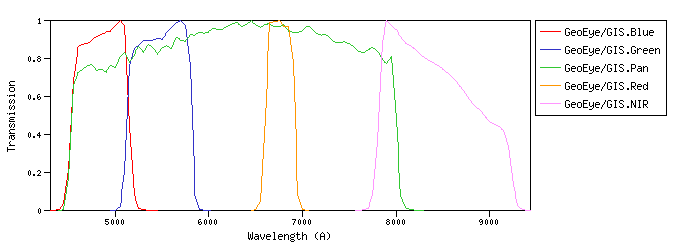
GeoEye :The GeoEye-1 satellite sensor was successfully launched on September 6, 2008. GeoEye-1 is capable of acquiring image data at 0.46 meter panchromatic (B&W) and 1.84 meter multispectral resolution. GeoEye/GIS :GIS (GeoEye Imaging System) is a pushbroom imaging system whose basic elements are the optics subsystem (telescope assembly), the focal plane assembly (CCD detector), and the digital electronics subsystem.id:GeoEye/GIS.a |
| GeoEye/GIS.Blue | 4834.41 | 4845.28 | 4822.95 | 4406.67 | 5265.00 | 583.53 | 3981.82 | 5.11e-9 | GeoEye | GIS | GeoEye-1 GIS Blue normalized spectral response | | GeoEye/GIS.Green | 5466.38 | 5477.95 | 5455.13 | 5020.00 | 5898.00 | 646.13 | 3629.66 | 3.64e-9 | GeoEye | GIS | GeoEye-1 GIS Green normalized spectral response | | GeoEye/GIS.Pan | 6069.83 | 6302.43 | 5841.30 | 4451.56 | 8125.00 | 3074.36 | 3331.55 | 2.71e-9 | GeoEye | GIS | GeoEye-1 GIS Panchromatic normalized spectral response | | GeoEye/GIS.Red | 6755.31 | 6757.45 | 6754.72 | 6507.78 | 6996.25 | 316.31 | 2875.48 | 1.89e-9 | GeoEye | GIS | GeoEye-1 GIS Red normalized spectral response | | GeoEye/GIS.NIR | 8384.63 | 8412.42 | 8365.45 | 7685.00 | 9335.00 | 1011.88 | 2313.73 | 9.87e-10 | GeoEye | GIS | GeoEye-1 GIS NIR normalized spectral response |
| Filter Plots
 |
|
| 


