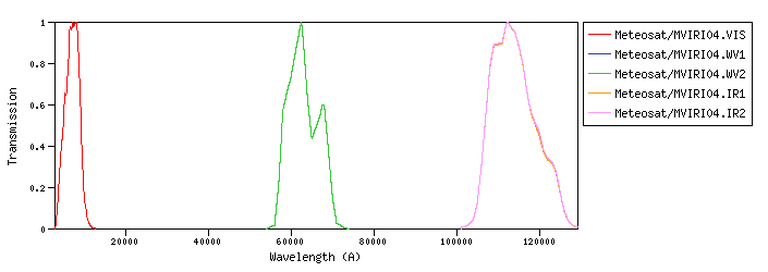
Meteosat :Meteosat is the European meteorological program in GEO (Geostationary Orbit) that was initiated in 1972 by ESRO (European Space Research Organization). Meteosat/MVIRI04 :Meteosat Visible Infra-Red Imager (MVIRI) on board Meteosat-04id:Meteosat/MVIRI04.a |
| Meteosat/MVIRI04.VIS | 6489.55 | 7101.87 | 6051.19 | 3070.99 | 11825.61 | 4409.73 | 3052.36 | 2.17e-9 | Meteosat | Meteosat-MVIRI | Meteosat04 MVIRI VIS normalized SRF | | Meteosat/MVIRI04.WV1 | 62729.45 | 63019.92 | 62278.38 | 54998.60 | 72497.68 | 8249.62 | 93.77 | 7.14e-13 | Meteosat | Meteosat-MVIRI | Meteosat04 MVIRI WV1 normalized SRF | | Meteosat/MVIRI04.WV2 | 62729.45 | 63019.92 | 62278.38 | 54998.60 | 72497.68 | 8249.62 | 93.77 | 7.14e-13 | Meteosat | Meteosat-MVIRI | Meteosat04 MVIRI WV2 normalized SRF | | Meteosat/MVIRI04.IR1 | 113670.95 | 114002.45 | 113141.36 | 102056.97 | 129190.58 | 12937.87 | 29.55 | 6.86e-14 | Meteosat | Meteosat-MVIRI | Meteosat04 MVIRI IR1 normalized SRF | | Meteosat/MVIRI04.IR2 | 113700.09 | 114033.52 | 113167.29 | 102065.89 | 129190.56 | 13028.18 | 29.53 | 6.85e-14 | Meteosat | Meteosat-MVIRI | Meteosat04 MVIRI IR2 normalized SRF |
| Filter Plots
 |
|
| 


