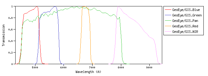
GeoEye :The GeoEye-1 satellite sensor was successfully launched on September 6, 2008. GeoEye-1 is capable of acquiring image data at 0.46 meter panchromatic (B&W) and 1.84 meter multispectral resolution. GeoEye/GIS :GIS (GeoEye Imaging System) is a pushbroom imaging system whose basic elements are the optics subsystem (telescope assembly), the focal plane assembly (CCD detector), and the digital electronics subsystem.id:GeoEye/GIS.a |
| GeoEye/GIS.Blue | 4834.41 | 4845.28 | 4822.95 | 4406.67 | 5265.00 | 583.53 | 3981.82 | 5.11e-9 | GeoEye | GIS | GeoEye-1 GIS Blue normalized spectral response | | GeoEye/GIS.Green | 5466.38 | 5477.95 | 5455.13 | 5020.00 | 5898.00 | 646.13 | 3629.66 | 3.64e-9 | GeoEye | GIS | GeoEye-1 GIS Green normalized spectral response | | GeoEye/GIS.Pan | 6069.83 | 6302.43 | 5841.30 | 4451.56 | 8125.00 | 3074.36 | 3331.55 | 2.71e-9 | GeoEye | GIS | GeoEye-1 GIS Panchromatic normalized spectral response | | GeoEye/GIS.Red | 6755.31 | 6757.45 | 6754.72 | 6507.78 | 6996.25 | 316.31 | 2875.48 | 1.89e-9 | GeoEye | GIS | GeoEye-1 GIS Red normalized spectral response | | GeoEye/GIS.NIR | 8384.63 | 8412.42 | 8365.45 | 7685.00 | 9335.00 | 1011.88 | 2313.73 | 9.87e-10 | GeoEye | GIS | GeoEye-1 GIS NIR normalized spectral response |
| Filter Plots
 |
|
| 
 ≡ filter transmission<p><u>Property info:</u><ul><li><b>Unit</b>:Angstrom<li><b>UCD</b>:em.wl</ul></td></table>',WIDTH,400))
 ≡ filter transmission<br> Vg(λ) ≡ Vega spectrum.<p><u>More info:</u><p>Vega spectrum from calspec database.<ul><li><a href="https://ui.adsabs.harvard.edu/abs/2014PASP..126..711B/abstract" target="_blank">Bohlin, Gordon, & Tremblay (2014)</a>.<li><a href="https://www.stsci.edu/hst/instrumentation/reference-data-for-calibration-and-tools/astronomical-catalogs/calspec" target="_blank">STScI current calspec</a>.<li><a href="morefiles/vega.dat" target="_blank">Vega spectrum file</a> (units: Angstrom erg/cm2/s/A).</ul><p><u>Property info:</u><ul><li><b>Unit</b>:Angstrom<li><b>UCD</b>:em.wl.effective</ul></td></table>',WIDTH,400))
 ≡ filter transmission<p>Equivalent to the horizontal size of a rectangle with height equal to maximum transmission and with the same area that the one covered by the filter transmission curve.<p><u>Property info:</u><ul><li><b>Unit</b>:Angstrom<li><b>UCD</b>:instr.bandwidth<li><b>Utype</b>: <i>photdm:PhotometryFilter.bandwidth.extent.value</i></ul></td></table>',WIDTH,400))
 ≡ filter transmission (energy counter).<br> Vg(λ) ≡ Vega spectrum.<p><i>(T(λ) must be multiplied by λ for photon counting devices)</i><p>F<sub>0,ν</sub>(Jy) = (2.9979246)<sup>-1</sup> 10<sup>5</sup> * λ<sub>ref</sub><sup>2</sup> * F<sub>0,λ</sub>(erg/cm<sup>2</sup>/s/A)<p>In the case that filter owner specifies its own values, they will be the ones provided by the service when queried through the VO.<p><u>Property info:</u><ul><li><b>Unit</b>:Jy<li><b>UCD</b>:phot.flux.density<li><b>Utype</b>: <i>photdm:PhotCal.zeroPoint.flux.value</i></ul></td></table>',WIDTH,400))
 ≡ filter transmission (energy counter).<br> Vg(λ) ≡ Vega spectrum.<p><i>(T(λ) must be multiplied by λ for photon counting devices)</i><p><u>Property info:</u><ul><li><b>Unit</b>:erg/cm2/s/A<li><b>Utype</b>: <i>PhotCal.ZeroPoint</i></ul></td></table>',WIDTH,400))