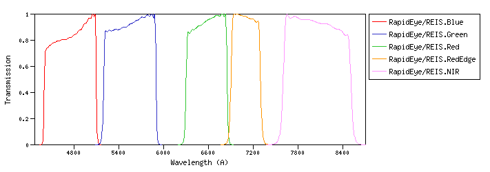
RapidEye :RapidEye is a full end-to-end commercial Earth Observation system comprising a constellation of five minisatellites, a dedicated SCC (Spacecraft Control Center), a data downlink ground station service, and a full ground segment designed to plan, acquire and process up to 5 million km2 of imagery every day to generate unique land information products. RapidEye/REIS :REIS (RapidEye Earth Imaging System).id:RapidEye/REIS.a |
| RapidEye/REIS.Blue | 4755.55 | 4768.62 | 4740.31 | 4376.13 | 5129.53 | 593.29 | 4056.39 | 5.38e-9 | RapidEye | REIS | RapidEye REIS Blue normalized spectral response | | RapidEye/REIS.Green | 5545.46 | 5556.78 | 5534.38 | 5145.20 | 5934.06 | 654.12 | 3578.29 | 3.49e-9 | RapidEye | REIS | RapidEye REIS Green normalized spectral response | | RapidEye/REIS.Red | 6576.35 | 6582.17 | 6570.59 | 6250.96 | 6890.20 | 519.48 | 2913.11 | 2.02e-9 | RapidEye | REIS | RapidEye REIS Red normalized spectral response | | RapidEye/REIS.RedEdge | 7094.03 | 7096.96 | 7090.79 | 6835.81 | 7363.32 | 393.27 | 2750.99 | 1.64e-9 | RapidEye | REIS | RapidEye REIS RedEdge normalized spectral response | | RapidEye/REIS.NIR | 8028.81 | 8041.96 | 8014.31 | 7494.95 | 8602.74 | 854.77 | 2384.42 | 1.11e-9 | RapidEye | REIS | RapidEye REIS NIR normalized spectral response |
| Filter Plots
 |
|
| 


