Landsat :Landsat 8 provides moderate-resolution (15m-100m, depending on spectral frequency) measurements of the Earth's terrestrial and polar regions in the visible, near-infrared, short wave infrared, and thermal infrared. Landsat/MSS-2 :Multispectral Scanner System (MSS) instrument on board Landsat-2id:Landsat/MSS-2.a |
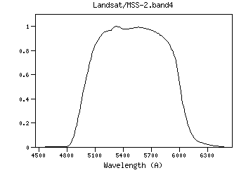
| Landsat/MSS-2.band4 | 5472.80 | 5499.72 | 5447.41 | 4811.43 | 6400.00 | 1000.37 | 3627.35 | 3.63e-9 | Landsat | MSS | Landsat-2 MSS band4 RSR | | Landsat/MSS-2.band4 | Filter Description | Filter ID (?) : | Landsat/MSS-2.band4 |
| Description (?) : | Landsat-2 MSS band4 RSR |
| Phot.System (?) : | MSS |
| Detector Type (?) : | Energy counter |
| Band Name (?) : | ------ |
| Obs. Facility (?) : | Landsat |
| Instrument (?) : | MSS |
| Comments (?) : | ------ |
| | Mathematical properties | Property | Calculated | Specified | Unit | | λref (?) : |
5472.80 | ------- | (Angstrom) |
| λmean (?) : |
5499.72 | ------- | (Angstrom) |
| λcen (?) : |
5493.33 | ------- | (Angstrom) |
| λeff (?) : |
5447.41 | ------- | (Angstrom) |
| λpeak (?) : |
5320.00 | ------- | (Angstrom) |
| λpivot (?) : |
5472.80 | ------- | (Angstrom) |
| λphot (?) : |
5465.12 | ------- | (Angstrom) |
| λmin (?) : |
4811.43 | ------- | (Angstrom) |
| λmax (?) : |
6400.00 | ------- | (Angstrom) |
| Weff (?) : |
1000.37 | ------- | (Angstrom) |
| FWHM (?) : |
1020.70 | ------- | (Angstrom) |
| Af/AV (?) : |
1.01 | ------- | () |
| Fsun (?) : |
185.40 | ------- | (erg/cm2/s/A) |
| Transmission

Data file: ascii, VOTable Reference for filter response:
MSS RSR Transmission components: Filter + Instrumentid:Landsat/MSS-2.band4 | | Calibration properties
Vega System | Property | Specified | Calculated | Unit | | Zero Point (?) : |
------- |
3.6307e-9 | (erg/cm2/s/A) |
| |
------- |
3627.35 | (Jy) |
| ZP Type (?) : |
Pogson |
| PhotCal ID (?) : |
Landsat/MSS-2.band4/Vega |
| |
AB System | Property | Specified | Calculated | Unit | | Zero Point (?) : |
------- |
3.63436e-9 | (erg/cm2/s/A) |
| |
------- |
3631.00 | (Jy) |
| ZP Type (?) : |
Pogson |
| PhotCal ID (?) : |
Landsat/MSS-2.band4/AB |
| |
ST System | Property | Specified | Calculated | Unit | | Zero Point (?) : |
------- |
3.631e-9 | (erg/cm2/s/A) |
| |
------- |
3627.64 | (Jy) |
| ZP Type (?) : |
Pogson |
| PhotCal ID (?) : |
Landsat/MSS-2.band4/ST |
| |
|
Filter added: 2020-09-27 21:58:45
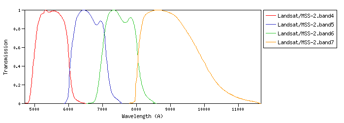
Last update: 2021-07-27 20:05:53 | | Landsat/MSS-2.band5 | 6583.79 | 6607.92 | 6558.73 | 5907.50 | 7545.45 | 1000.74 | 2953.41 | 2.04e-9 | Landsat | MSS | Landsat-2 MSS band5 RSR | | Landsat/MSS-2.band6 | 7495.74 | 7519.63 | 7469.50 | 6710.00 | 8496.00 | 1044.52 | 2588.81 | 1.38e-9 | Landsat | MSS | Landsat-2 MSS band6 RSR | | Landsat/MSS-2.band7 | 9027.57 | 9104.38 | 8979.72 | 7835.00 | 11570.00 | 1884.88 | 2232.87 | 8.21e-10 | Landsat | MSS | Landsat-2 MSS band7 RSR |
| Filter Plots
 |
|
| 


