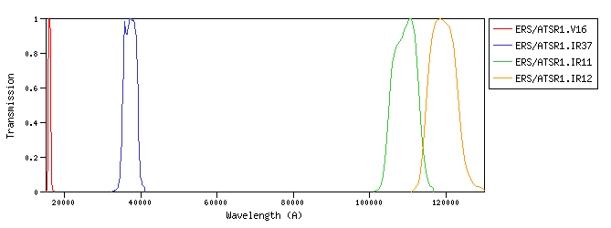
ERS :ESA's two European Remote Sensing (ERS) satellites, ERS-1 and -2, were launched into the same orbit in 1991 and 1995 respectively. ERS/ATSR1 :The ATSR (Along Track Scanning Radiometer) instrument on board ERS-1 produces infrared images of the Earth at a spatial resolution of one km.id:ERS/ATSR1.a |
| ERS/ATSR1.V16 | 16052.34 | 16058.91 | 16044.87 | 15286.80 | 16923.05 | 774.68 | 1032.49 | 1.2e-10 | ERS | ATSR1 | ERS ATSR1 V 1.6mic band normalized SRF | | ERS/ATSR1.IR37 | 37199.11 | 37271.31 | 37083.77 | 33264.48 | 41060.00 | 4140.54 | 248.14 | 5.38e-12 | ERS | ATSR1 | ERS ATSR1 IR 3.7mic band normalized SRF | | ERS/ATSR1.IR11 | 109188.76 | 109284.95 | 109032.73 | 102301.54 | 116640.00 | 7657.46 | 31.82 | 8.0e-14 | ERS | ATSR1 | ERS ATSR1 IR 11mic band normalized SRF | | ERS/ATSR1.IR12 | 119145.64 | 119263.36 | 118953.40 | 111374.40 | 130055.76 | 8839.22 | 26.84 | 5.67e-14 | ERS | ATSR1 | ERS ATSR1 IR 12mic band normalized SRF |
| Filter Plots
 |
|
| 


