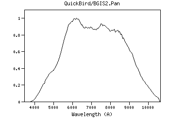
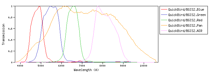
QuickBird :QuickBird-2 is an imaging satellite of DigitalGlobe Inc. (formerly EarthWatch) of Longmont, CO, USA, offering commercial imagery at 0.61 m (PAN) and at 2.4 m (MS) resolution. QuickBird/BGIS2 :BGIS 2000 (Ball Global Imaging System 2000) is a BATC-developed imager.id:QuickBird/BGIS2.a |
| QuickBird/BGIS2.Blue | 4842.71 | 4916.61 | 4804.40 | 4176.14 | 9229.21 | 682.51 | 3973.59 | 5.08e-9 | QuickBird | BGIS | QuickBird-02 BGIS Blue normalized spectral response | | QuickBird/BGIS2.Green | 5457.44 | 5512.65 | 5417.49 | 4451.12 | 6833.00 | 991.61 | 3632.98 | 3.66e-9 | QuickBird | BGIS | QuickBird-02 BGIS Green normalized spectral response | | QuickBird/BGIS2.Red | 6510.01 | 6542.20 | 6481.33 | 5590.77 | 7495.45 | 712.58 | 2973.42 | 2.1e-9 | QuickBird | BGIS | QuickBird-02 BGIS Red normalized spectral response | | QuickBird/BGIS2.Pan | 6748.58 | 7181.22 | 6341.66 | 3839.04 | 10600.00 | 3975.76 | 3068.31 | 2.02e-9 | QuickBird | BGIS | QuickBird-02 BGIS Panchromatic normalized spectral response | | QuickBird/BGIS2.Pan | Filter Description | Filter ID (?) : | QuickBird/BGIS2.Pan |
| Description (?) : | QuickBird-02 BGIS Panchromatic normalized spectral response |
| Phot.System (?) : | BGIS |
| Detector Type (?) : | Energy counter |
| Band Name (?) : | ------ |
| Obs. Facility (?) : | QuickBird |
| Instrument (?) : | BGIS |
| Comments (?) : | ------ |
| | Mathematical properties | Property | Calculated | Specified | Unit | | λref (?) : |
6748.58 | ------- | (Angstrom) |
| λmean (?) : |
7181.22 | ------- | (Angstrom) |
| λcen (?) : |
7248.94 | ------- | (Angstrom) |
| λeff (?) : |
6341.66 | ------- | (Angstrom) |
| λpeak (?) : |
6200.00 | ------- | (Angstrom) |
| λpivot (?) : |
6748.58 | ------- | (Angstrom) |
| λphot (?) : |
6622.60 | ------- | (Angstrom) |
| λmin (?) : |
3839.04 | ------- | (Angstrom) |
| λmax (?) : |
10600.00 | ------- | (Angstrom) |
| Weff (?) : |
3975.76 | ------- | (Angstrom) |
| FWHM (?) : |
3993.01 | ------- | (Angstrom) |
| Af/AV (?) : |
0.773 | ------- | () |
| Fsun (?) : |
138.31 | ------- | (erg/cm2/s/A) |
| Transmission

Data file: ascii, VOTable Reference for filter response:
Apollo Mapping Transmission components: Filter + Instrumentid:QuickBird/BGIS2.Pan | | Calibration properties
Vega System | Property | Specified | Calculated | Unit | | Zero Point (?) : |
------- |
2.01974e-9 | (erg/cm2/s/A) |
| |
------- |
3068.31 | (Jy) |
| ZP Type (?) : |
Pogson |
| PhotCal ID (?) : |
QuickBird/BGIS2.Pan/Vega |
| |
AB System | Property | Specified | Calculated | Unit | | Zero Point (?) : |
------- |
2.39013e-9 | (erg/cm2/s/A) |
| |
------- |
3631.00 | (Jy) |
| ZP Type (?) : |
Pogson |
| PhotCal ID (?) : |
QuickBird/BGIS2.Pan/AB |
| |
ST System | Property | Specified | Calculated | Unit | | Zero Point (?) : |
------- |
3.631e-9 | (erg/cm2/s/A) |
| |
------- |
5516.08 | (Jy) |
| ZP Type (?) : |
Pogson |
| PhotCal ID (?) : |
QuickBird/BGIS2.Pan/ST |
| |
|
Filter added: 2020-08-31 10:46:36
Last update: 2021-07-27 20:31:14 | | QuickBird/BGIS2.NIR | 8001.77 | 8092.92 | 7918.77 | 5417.88 | 9350.66 | 1142.33 | 2404.32 | 1.13e-9 | QuickBird | BGIS | QuickBird-02 BGIS NIR normalized spectral response |
| Filter Plots
 |
|
| 


