Landsat :Landsat 8 provides moderate-resolution (15m-100m, depending on spectral frequency) measurements of the Earth's terrestrial and polar regions in the visible, near-infrared, short wave infrared, and thermal infrared. Landsat/MSS-1 :Multispectral Scanner System (MSS) instrument on board Landsat-1id:Landsat/MSS-1.a |
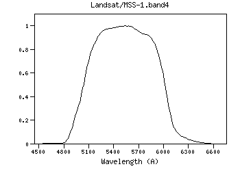
| Landsat/MSS-1.band4 | 5503.41 | 5530.16 | 5477.99 | 4800.00 | 6480.00 | 971.32 | 3608.01 | 3.57e-9 | Landsat | MSS | Landsat-1 MSS band4 RSR | | Landsat/MSS-1.band4 | Filter Description | Filter ID (?) : | Landsat/MSS-1.band4 |
| Description (?) : | Landsat-1 MSS band4 RSR |
| Phot.System (?) : | MSS |
| Detector Type (?) : | Energy counter |
| Band Name (?) : | ------ |
| Obs. Facility (?) : | Landsat |
| Instrument (?) : | MSS |
| Comments (?) : | ------ |
| | Mathematical properties | Property | Calculated | Specified | Unit | | λref (?) : |
5503.41 | ------- | (Angstrom) |
| λmean (?) : |
5530.16 | ------- | (Angstrom) |
| λcen (?) : |
5530.17 | ------- | (Angstrom) |
| λeff (?) : |
5477.99 | ------- | (Angstrom) |
| λpeak (?) : |
5540.00 | ------- | (Angstrom) |
| λpivot (?) : |
5503.41 | ------- | (Angstrom) |
| λphot (?) : |
5495.60 | ------- | (Angstrom) |
| λmin (?) : |
4800.00 | ------- | (Angstrom) |
| λmax (?) : |
6480.00 | ------- | (Angstrom) |
| Weff (?) : |
971.32 | ------- | (Angstrom) |
| FWHM (?) : |
983.00 | ------- | (Angstrom) |
| Af/AV (?) : |
1.00 | ------- | () |
| Fsun (?) : |
184.94 | ------- | (erg/cm2/s/A) |
| Transmission
Data file: ascii, VOTable Reference for filter response:
MSS RSR Transmission components: Filter + Instrumentid:Landsat/MSS-1.band4 | | Calibration properties
Vega System | Property | Specified | Calculated | Unit | | Zero Point (?) : |
------- |
3.57128e-9 | (erg/cm2/s/A) |
| |
------- |
3608.01 | (Jy) |
| ZP Type (?) : |
Pogson |
| PhotCal ID (?) : |
Landsat/MSS-1.band4/Vega |
| |
AB System | Property | Specified | Calculated | Unit | | Zero Point (?) : |
------- |
3.59404e-9 | (erg/cm2/s/A) |
| |
------- |
3631.00 | (Jy) |
| ZP Type (?) : |
Pogson |
| PhotCal ID (?) : |
Landsat/MSS-1.band4/AB |
| |
ST System | Property | Specified | Calculated | Unit | | Zero Point (?) : |
------- |
3.631e-9 | (erg/cm2/s/A) |
| |
------- |
3668.34 | (Jy) |
| ZP Type (?) : |
Pogson |
| PhotCal ID (?) : |
Landsat/MSS-1.band4/ST |
| |
|
Filter added: 2020-09-27 21:57:13
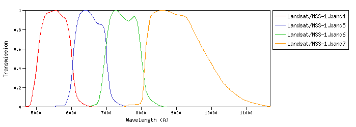
Last update: 2021-07-27 20:05:51 | | Landsat/MSS-1.band5 | 6510.08 | 6532.36 | 6485.89 | 5570.00 | 7490.00 | 944.00 | 2988.69 | 2.11e-9 | Landsat | MSS | Landsat-1 MSS band5 RSR | | Landsat/MSS-1.band6 | 7462.44 | 7486.64 | 7436.00 | 6555.00 | 8555.00 | 1046.15 | 2601.85 | 1.4e-9 | Landsat | MSS | Landsat-1 MSS band6 RSR | | Landsat/MSS-1.band7 | 9057.66 | 9133.24 | 9010.38 | 7550.00 | 11563.33 | 1859.80 | 2229.12 | 8.15e-10 | Landsat | MSS | Landsat-1 MSS band7 RSR |
| Filter Plots
 |
|
| 
 ≡ filter transmission<p><u>Property info:</u><ul><li><b>Unit</b>:Angstrom<li><b>UCD</b>:em.wl</ul></td></table>',WIDTH,400))
 ≡ filter transmission<br> Vg(λ) ≡ Vega spectrum.<p><u>More info:</u><p>Vega spectrum from calspec database.<ul><li><a href="https://ui.adsabs.harvard.edu/abs/2014PASP..126..711B/abstract" target="_blank">Bohlin, Gordon, & Tremblay (2014)</a>.<li><a href="https://www.stsci.edu/hst/instrumentation/reference-data-for-calibration-and-tools/astronomical-catalogs/calspec" target="_blank">STScI current calspec</a>.<li><a href="morefiles/vega.dat" target="_blank">Vega spectrum file</a> (units: Angstrom erg/cm2/s/A).</ul><p><u>Property info:</u><ul><li><b>Unit</b>:Angstrom<li><b>UCD</b>:em.wl.effective</ul></td></table>',WIDTH,400))
 ≡ filter transmission<p>Equivalent to the horizontal size of a rectangle with height equal to maximum transmission and with the same area that the one covered by the filter transmission curve.<p><u>Property info:</u><ul><li><b>Unit</b>:Angstrom<li><b>UCD</b>:instr.bandwidth<li><b>Utype</b>: <i>photdm:PhotometryFilter.bandwidth.extent.value</i></ul></td></table>',WIDTH,400))
 ≡ filter transmission (energy counter).<br> Vg(λ) ≡ Vega spectrum.<p><i>(T(λ) must be multiplied by λ for photon counting devices)</i><p>F<sub>0,ν</sub>(Jy) = (2.9979246)<sup>-1</sup> 10<sup>5</sup> * λ<sub>ref</sub><sup>2</sup> * F<sub>0,λ</sub>(erg/cm<sup>2</sup>/s/A)<p>In the case that filter owner specifies its own values, they will be the ones provided by the service when queried through the VO.<p><u>Property info:</u><ul><li><b>Unit</b>:Jy<li><b>UCD</b>:phot.flux.density<li><b>Utype</b>: <i>photdm:PhotCal.zeroPoint.flux.value</i></ul></td></table>',WIDTH,400))
 ≡ filter transmission (energy counter).<br> Vg(λ) ≡ Vega spectrum.<p><i>(T(λ) must be multiplied by λ for photon counting devices)</i><p><u>Property info:</u><ul><li><b>Unit</b>:erg/cm2/s/A<li><b>Utype</b>: <i>PhotCal.ZeroPoint</i></ul></td></table>',WIDTH,400))
 ≡ filter transmission<p>f(λ) ≡ flux of the spectrum<p><u>Property info:</u><ul><li><b>UCD</b>:meta.code<li><b>Utype</b>: <i>photdm:PhotometricSystem.detectorType</i></ul></td></table>',WIDTH,400))
 ≡ filter transmission<p><img src=showgraph.php?what=lmean&val=5530.1609681213&id=Landsat/MSS-1.band4><p><u>Property info:</u><ul><li><b>Unit</b>:Angstrom<li><b>UCD</b>:em.wl</ul></td></table>',STICKY,true,CLOSEBTN,true,WIDTH,400))
 ≡ filter transmission<br> Vg(λ) ≡ Vega spectrum.<p><img src=showgraph.php?what=leff&val=5477.9861685203&id=Landsat/MSS-1.band4><p><u>More info:</u><p>Vega spectrum from calspec database.<ul><li><a href="https://ui.adsabs.harvard.edu/abs/2014PASP..126..711B/abstract" target="_blank">Bohlin, Gordon, & Tremblay (2014)</a>.<li><a href="https://www.stsci.edu/hst/instrumentation/reference-data-for-calibration-and-tools/astronomical-catalogs/calspec" target="_blank">STScI current calspec</a>.<li><a href="morefiles/vega.dat" target="_blank">Vega spectrum file</a> (units: Angstrom erg/cm2/s/A).</ul><p><u>Property info:</u><ul><li><b>Unit</b>:Angstrom<li><b>UCD</b>:em.wl.effective</ul></td></table>',STICKY,true,CLOSEBTN,true,WIDTH,400))
 ≡ filter transmission<p><img src=showgraph.php?what=lpiv&val=5503.4126151419&id=Landsat/MSS-1.band4><p><u>Property info:</u><ul><li><b>Unit</b>:Angstrom<li><b>UCD</b>:em.wl</ul></td></table>',STICKY,true,CLOSEBTN,true,WIDTH,400))
 ≡ filter transmission<br> Vg(λ) ≡ Vega spectrum<p><img src=showgraph.php?what=lphot&val=5495.5954896872&id=Landsat/MSS-1.band4><p><u>More info:</u><p>Vega spectrum from calspec database.<ul><li><a href="https://ui.adsabs.harvard.edu/abs/2014PASP..126..711B/abstract" target="_blank">Bohlin, Gordon, & Tremblay (2014)</a>.<li><a href="https://www.stsci.edu/hst/instrumentation/reference-data-for-calibration-and-tools/astronomical-catalogs/calspec" target="_blank">STScI current calspec</a>.<li><a href="morefiles/vega.dat" target="_blank">Vega spectrum file</a> (units: Angstrom erg/cm2/s/A).</ul><p><u>Property info:</u><ul><li><b>Unit</b>:Angstrom<li><b>UCD</b>:em.wl</ul></td></table>',STICKY,true,CLOSEBTN,true,WIDTH,400))
 ≡ filter transmission<p>Equivalent to the horizontal size of a rectangle with height equal to maximum transmission and with the same area that the one covered by the filter transmission curve.<p><img src=showgraph.php?what=weff&val=971.31990866406,5530.1666666667,1&id=Landsat/MSS-1.band4><p><u>Property info:</u><ul><li><b>Unit</b>:Angstrom<li><b>UCD</b>:instr.bandwidth<li><b>Utype</b>: <i>photdm:PhotometryFilter.bandwidth.extent.value</i></ul></td></table>',STICKY,true,CLOSEBTN,true,WIDTH,400))
</a> improved by <a href="http://adsabs.harvard.edu/abs/2005ApJ...619..931I" target="_blank">Indebetouw et al (2005)</a> in the infrared. <p><img src="images/extlaw.png"><p>You can download the corresponding <a href=\"getextlaw.php\" target=\"_blank\">data file</a> for the opacity k<sub>λ</sub>. The extinction at each wavelength is calculated as: A<sub>λ</sub> = A<sub>V</sub> * k<sub>λ</sub>/k<sub>V</sub>, where k<sub>λ</sub> is the opacity for a given λ and k<sub>V</sub>=211.4<p><p><u>Property info:</u><ul></ul></td></table>',STICKY,true,CLOSEBTN,true,WIDTH,400))
 ≡ filter transmission.<br> Sun(λ) ≡ Sun spectrum.<p><img src="images/sun.png"><p><p><u>More info:</u><p>Sun spectrum from calspec database: sun_reference_stis_002 composed with sun_mod_001 for larger wavelengths.<ul><li><a href="https://ui.adsabs.harvard.edu/abs/2014PASP..126..711B/abstract" target="_blank">Bohlin, Gordon, & Tremblay (2014)</a>.<li><a href="https://www.stsci.edu/hst/instrumentation/reference-data-for-calibration-and-tools/astronomical-catalogs/calspec" target="_blank">STScI current calspec</a>.<li><a href="morefiles/sun.dat" target="_blank">Sun composed spectrum</a> (units: Angstrom erg/cm2/s/A).</ul><p><u>Property info:</u><ul><li><b>Unit</b>:erg/cm2/s/A<li><b>UCD</b>:phot.flux.density</ul></td></table>',STICKY,true,CLOSEBTN,true,WIDTH,400))
 ≡ filter transmission.<br> Vg(λ) ≡ Vega spectrum.<p>F<sub>0,ν</sub>(Jy) = (2.9979246)<sup>-1</sup> 10<sup>5</sup> * λ<sub>ref</sub><sup>2</sup> * F<sub>0,λ</sub>(erg/cm<sup>2</sup>/s/A)<p>In the case that filter owner specifies its own values, they will be the ones provided by the service when queried through the VO.<p><u>VO PhotDM Utypes</u>: <br><i>PhotCal.MagnitudeSystem.type</i> -> VEGAmag <br><i>PhotCal.ZeroPoint.Flux.value</i> -> F<sub>0</sub><p><u>More info:</u><p>Vega spectrum from calspec database.<ul><li><a href="https://ui.adsabs.harvard.edu/abs/2014PASP..126..711B/abstract" target="_blank">Bohlin, Gordon, & Tremblay (2014)</a>.<li><a href="https://www.stsci.edu/hst/instrumentation/reference-data-for-calibration-and-tools/astronomical-catalogs/calspec" target="_blank">STScI current calspec</a>.<li><a href="morefiles/vega.dat" target="_blank">Vega spectrum file</a> (units: Angstrom erg/cm2/s/A).</ul><p><u>Property info:</u><ul><li><b>UCD</b>:phot.flux.density<li><b>Utype</b>: <i>photdm:PhotCal.ZeroPoint.Flux.value</i></ul></td></table>',STICKY,true,CLOSEBTN,true,WIDTH,400))