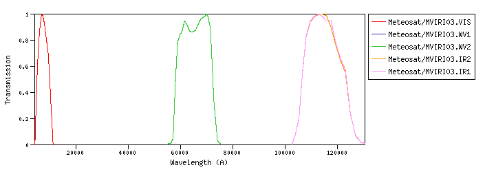
Meteosat :Meteosat is the European meteorological program in GEO (Geostationary Orbit) that was initiated in 1972 by ESRO (European Space Research Organization). Meteosat/MVIRI03 :Meteosat Visible Infra-Red Imager (MVIRI) on board Meteosat-03id:Meteosat/MVIRI03.a |
| Meteosat/MVIRI03.VIS | 6916.19 | 7418.45 | 6458.48 | 4179.83 | 11151.12 | 4532.20 | 3027.55 | 1.9e-9 | Meteosat | Meteosat-MVIRI | Meteosat03 MVIRI VIS normalized SRF | | Meteosat/MVIRI03.WV1 | 64962.50 | 65388.88 | 64286.71 | 55463.51 | 75024.71 | 13359.22 | 88.20 | 6.27e-13 | Meteosat | Meteosat-MVIRI | Meteosat03 MVIRI WV1 normalized SRF | | Meteosat/MVIRI03.WV2 | 64962.50 | 65388.88 | 64286.71 | 55463.51 | 75024.71 | 13359.22 | 88.20 | 6.27e-13 | Meteosat | Meteosat-MVIRI | Meteosat03 MVIRI WV2 normalized SRF | | Meteosat/MVIRI03.IR2 | 114485.12 | 114859.98 | 113878.82 | 102757.51 | 130484.63 | 15976.92 | 29.17 | 6.67e-14 | Meteosat | Meteosat-MVIRI | Meteosat03 MVIRI IR2 normalized SRF | | Meteosat/MVIRI03.IR1 | 114524.29 | 114900.74 | 113914.59 | 102757.50 | 130296.17 | 16103.46 | 29.15 | 6.66e-14 | Meteosat | Meteosat-MVIRI | Meteosat03 MVIRI IR1 normalized SRF |
| Filter Plots
 |
|
| 


